New Delhi, 15 August
7.7-Magnitude Earthquake Hits Indonesia, Kills at Least 38; Buildings Collapse
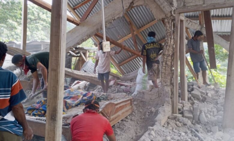
A powerful magnitude 7.7 earthquake struck off Indonesia’s Flores island early Saturday, August 15, killing at least 38 people, injuring several others and causing widespread damage, building collapses and landslides. 7.7-Magnitude Earthquake Hits Indonesia, Kills at Least 38; Buildings Collapse
The shallow earthquake triggered panic across parts of eastern Indonesia and briefly prompted authorities to issue a tsunami warning for several coastal areas. The warning was later lifted after authorities found no significant sea-level changes posing a threat to coastal communities. 7.7-Magnitude Earthquake Hits Indonesia, Kills at Least 38; Buildings Collapse
Rescue teams continued searching affected areas as landslides, damaged roads and communication disruptions complicated emergency operations.
7.7 earthquake strikes Flores region
According to the US Geological Survey, the earthquake struck the Flores region at around 5:58 am local time, at a depth of about 10 kilometres. The epicentre was reported around 68 kilometres north-northwest of Ende in East Nusa Tenggara province. 7.7-Magnitude Earthquake Hits Indonesia, Kills at Least 38; Buildings Collapse
The main quake was followed by several aftershocks, adding to concerns among residents and emergency responders.
The earthquake caused severe damage in parts of East Nusa Tenggara, with reports of collapsed buildings, damaged homes, landslides and power outages.
Landslides hamper rescue operations
Landslides triggered by the earthquake buried homes and blocked roads in several areas.
A landslide in Reok village in Manggarai was among the areas reporting significant casualties. Rescue teams were deployed to search through mud and debris for people who may have been trapped.
The damage also affected transportation links, with landslides cutting sections of the Trans-Flores highway, a major road connecting communities across the island.
Authorities said communication disruptions and power outages were making it difficult to collect information about casualties and damage from remote areas.
Hospitals evacuate patients
The strong shaking also affected hospitals and other public facilities.
Local television footage showed patients being evacuated from hospital buildings as a precaution. Medical staff moved beds, oxygen cylinders, IV equipment and other supplies outdoors and established temporary treatment areas. 7.7-Magnitude Earthquake Hits Indonesia, Kills at Least 38; Buildings Collapse
Emergency authorities also deployed a helicopter to support rescue and relief operations, particularly in areas where damaged roads and the region’s island geography made access difficult.
Around 2,000 villagers in Nagekeo regency were reported to have fled their homes and moved to temporary shelters.
Tsunami warning later lifted
Following the offshore earthquake, Indonesian authorities issued a tsunami warning for parts of East Nusa Tenggara, West Nusa Tenggara, South Sulawesi and Southeast Sulawesi.
Residents in vulnerable coastal areas were urged to move away from beaches and riverbanks and seek higher ground.
The warning was later lifted after Indonesia’s meteorological and geophysical authorities found no significant sea-level changes that threatened coastal communities.
Earthquake felt across Flores
The powerful shaking was felt across large parts of Flores island and neighbouring regions.
Residents reported damage to buildings and widespread panic as people rushed outdoors or moved to higher ground.
At St Peter Major Seminary in Sikka, students attending morning Mass reportedly fled after part of a building collapsed. A priest was also reported to have suffered a broken leg after jumping from the second floor during the earthquake.
Damage was also reported in Labuan Bajo, a major gateway to Indonesia’s Komodo National Park, as well as Bima in neighbouring West Nusa Tenggara and parts of southern Sulawesi.
Indonesia remains highly earthquake-prone
Indonesia frequently experiences earthquakes and volcanic activity because it lies along the Pacific Ring of Fire, a region characterised by active faults and volcanoes. 7.7-Magnitude Earthquake Hits Indonesia, Kills at Least 38; Buildings Collapse
The country has experienced several devastating earthquakes and tsunamis in recent decades.
A powerful earthquake in 1992 triggered a tsunami on Flores that killed around 2,500 people. In 2018, a magnitude 7.5 earthquake and tsunami devastated parts of Sulawesi, while liquefaction caused extensive destruction in Palu.
The 2004 Indian Ocean earthquake and tsunami, which struck off Sumatra, was one of the deadliest natural disasters in modern history, killing around 230,000 people across countries bordering the Indian Ocean. 7.7-Magnitude Earthquake Hits Indonesia, Kills at Least 38; Buildings Collapse
Rescue and damage-assessment operations following Saturday’s earthquake remain ongoing, with authorities continuing to assess the full extent of the destruction.